Maps and Views (13)
![Submit a Featured Link: [$19.00]](/images/AddF_Button.gif)
![Submit a Regular Link: [$9.00]](/images/AddR_Button.gif)


 View San Diego Bay View San Diego Bay   - Shows San Diego Bay photographs and webcams from several viewpoints. - http://www.sdmis.org/view/    Points of Interest Map Points of Interest Map - Shows major roads and points of interest. Covers most of the city, but omits some northern and eastern areas. Provided by California Division of Tourism in pdf format. - http://gocalif.ca.gov/media/pages/getting_around/maps/SAN-DIEGO.pdf San Diego City Council Districts - Maps shows rough boundaries of each of the 8 districts. - http://www.sandiego.gov/citycouncil/ City of San Diego Neighborhoods Map - Map dividing the city into 8 areas, along with a list of the neighborhoods in each area. Links to each of the 8 areas provide more detailed maps. The result is that the locations of 100 neighborhoods are identified. - http://www.sandiego.gov/neighborhoods-map/ Directions to City Hall - Map showing downtown area near the City Administration Building, Civic Theater, and Golden Hall, along with parking facilities. - http://www.sandiego.gov/directories/servmap1.shtml Balboa Park Map - A clickable map with links to information about the park's facilities and monuments. - http://www.sandiego.gov/park-and-recreation/parks/balboa/facilities.shtml Downtown San Diego - Map shows streets, some major sites, and trolley lines. - http://www.sddt.com/Community/interactivemap.cfm?MapView=downtown San Diego Historical Society Photos - Large collection of historical photographs from the society's archives. - http://www.sandiegohistory.org/slideshow/mainphoto.htm Panorama of Map Room at UCSD - View of the map room at University of California San Diego. - http://govinfo.ucsd.edu/maps/panorama.html Historical map of San Diego in 1917 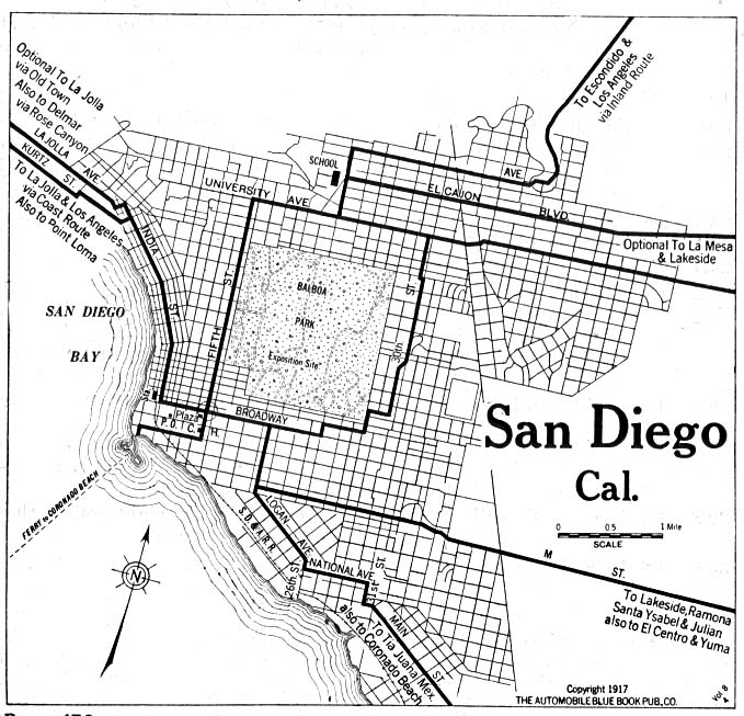 - Shows area around downtown San Diego. - http://www.lib.utexas.edu/maps/historical/san_diego_1917.jpg |
|